- Neighborhoods
-
Community
-
- Overview History Vision Newsroom News Releases Pilot Newsletter Media Contact Projects Volunteer
- Engage Milwaukie Events City Calendar Recreation Biking in Milwaukie Parks and Trails Directory North Clackamas Parks and Recreation Reserve a Room Library
- Schools North Clackamas School District MHS Student of the Month Public Safety Police Clackamas Fire District #1 Code Compliance Emergency Preparedness Emergency Notifications Garbage & Recycling
-
- Business
- Departments
-
Useful Links
-
- Jobs Alerts & Notifications Email Subscriptions Emergency Notifications Meetings City Services A-Z Mapping & GIS
- Contact the City Staff Directory Request a Public Record Report a Code Violation Report a Pothole Report Misconduct Schedule an Inspection Documents & Forms Documents and Reports Forms, Permits, and Applications
- Helpful Links Digital Archives Library Catalog Municipal Code Purchase a Parking Permit Paperless Billing Pay a Ticket or Utility Bill Urban Forest
-
29th Ave to Monroe St Connection
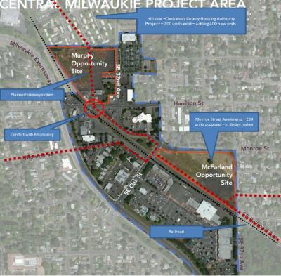
The City of Milwaukie is pursuing a State of Oregon grant to provide design assistance to come up with the best way to provide a safe bicycle connection between the proposed 29th Ave Neighborhood Greenway and the Monroe Street Neighborhood Greenway. There are two major projects underway in the Central Milwaukie area of Milwaukie. A 234-unit apartment complex is proposed on the McFarland Opportunity site (see map). This project is currently in design review. As proposed, the project provides an important bikeway link along the railroad through the back of the site that will connect to Washington Street and the Monroe Neighborhood Greenway to the east. The second big project is a master plan that was recently completed by the Clackamas County Housing Authority for the Hillside site. The County hopes to add 400 more affordable units to this site and the project will provide an important bike connection through the site connecting with the proposed 29th Ave Neighborhood Greenway to the north. In the City’s Transportation Systems Plan, a proposed bikeway continues south from Hillside through the undeveloped Murphy Opportunity site then crosses Harrison Street (an arterial) to connect to local streets, ultimately connecting to the rest of the system.
As City staff has worked on the Hillside, Murphy, and McFarland sites, it has become apparent that we will need approval of the railroad and a complex new signal system if we wish to cross Harrison at the planned location. This now appears impossible to achieve. We believe we need an alternative design that would route bike trips from Hillside to 32nd Ave. and then down 32nd Ave to connect with the rest of the system. This looks easy enough on the sketch below but in reality, the design of this solution will be very complicated given a tricky/busy intersection at Harrison St and 32nd Ave and the desire for this system to provide a safe, family-friendly connection between the Neighborhood Greenways. The City will need additional ROW from the Murphy site to make this happen. We are looking for design assistance to help figure out an optimum solution in advance of any development permits being issued for the Hillside project or on the Murphy site since both projects will need to contribute to the project. We expect that we could see development proposals for Hillside as early as next year so it is important to develop a preferred plan now.
The City expects to hear whether this project has received grant funding by the end of October.


